

burn-scar-ca v1: an open model for burned area in Canadian wildfire imagery
I fine-tuned an open US wildfire model on Canadian fire perimeters. On Quebec boreal fires it never saw, false burns dropped from about 15% to under 2%. Here is how it was built, how it was tested, and what it still cannot tell you.
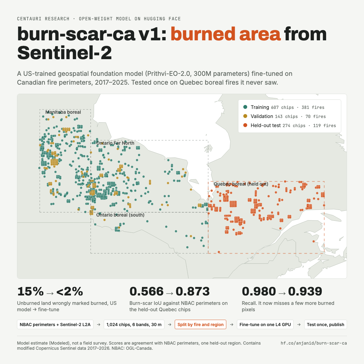
I've put my first open-weight model on Hugging Face. It's called burn-scar-ca, and it takes a Sentinel-2 satellite image of a Canadian wildfire after the fire and marks each 30 m pixel as burned or not burned.
What it produces is a model estimate of burned area, not a field survey. I'll come back to what that means for the scores.
Starting from an established open model
The starting point was Prithvi-EO-2.0-300M-BurnScars, an open 300-million-parameter geospatial foundation model that had already been fine-tuned on burn scars from US fires. It's the same idea as adapting a standard design to a new site: start from something already tested, then check it against local conditions.
When I ran it unchanged on Canadian boreal fires, it found almost every burned pixel (recall 0.98), but it also called about 15% of the unburned land burned. Its burn-scar IoU, which is the overlap between what the model marks as burned and the mapped fire perimeter, was 0.566.
Labels and imagery
So I fine-tuned it on Canadian fires. The labels are National Burned Area Composite (NBAC) fire perimeters for 2017 to 2025 from the Canadian Forest Service, for fires of 500 ha or more. The imagery is the least cloudy Sentinel-2 Level-2A surface reflectance scene within 45 days after each fire's end date, in the six bands the base model expects (blue, green, red, narrow near-infrared and two shortwave infrared bands), resampled to 30 m.
That came to 1,024 chips of 512 by 512 pixels, each about 15 km across. Cloud, shadow, snow, no-data pixels and scars from the previous three years are left out of the loss, so the model isn't graded on pixels nobody can actually see.
Testing it the way you'd accept work on site
The part I spent the most care on was the test split, and that's where my engineering background came in. On construction projects, acceptance testing is done independently of the crew that did the work, on samples the crew didn't pick.
Satellite data has its own version of that problem. If you split chips at random, neighbouring chips from the same fire end up on both sides of the split, and the test score looks better than it should. So the split is by fire and region:
- Training: 607 chips from 381 fires (Manitoba boreal, Ontario Far North and southern Ontario boreal)
- Validation: 143 chips from 70 fires
- Held-out test: 274 chips from 119 fires, every fire inside a Quebec boreal region
The Quebec fires were never used for training or tuning. They were scored once, at the end, against both the original US model and mine.
Training, and planning for the machine to disappear
Training ran on a single NVIDIA L4 GPU on Google Colab with TerraTorch and PyTorch: all weights trainable, AdamW at a learning rate of 1e-4, cross-entropy loss, bf16 mixed precision.
Colab ended my GPU runtime twice partway through with no error message, and the first time the checkpoints went with it. For the second attempt, the job wrote out the best weights as they improved and my laptop pulled them off the machine every 15 minutes. It's the same reason you don't keep the only copy of the as-builts in the site trailer.
The runtime died again, but the epoch-10 weights (validation loss 0.0572) were already safe, and those are the weights I published. A longer run may score differently.
Results on the held-out Quebec fires
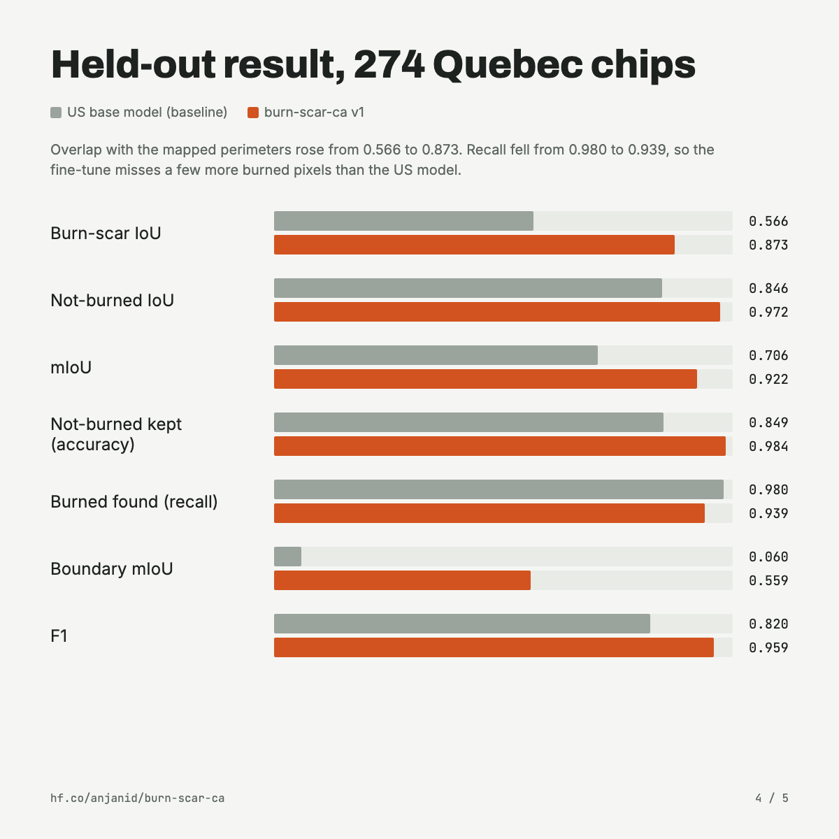
On the 274 held-out Quebec chips, US base model first, then burn-scar-ca v1:
- Burn-scar IoU: 0.566 → 0.873
- Not-burned IoU: 0.846 → 0.972
- mIoU: 0.706 → 0.922
- Not-burned accuracy: 0.849 → 0.984 (false burns fell from about 15% to under 2% of unburned pixels)
- Recall (burned pixels found): 0.980 → 0.939
- Boundary mIoU: 0.060 → 0.559
- F1: 0.820 → 0.959
Recall dropped a little, so the new model misses a few more burned pixels than the US one did. That's the trade for no longer painting large areas of unburned ground as burned.
Traceability
Every run, including the two that were cut short, is logged in MLflow with the code commit, the base-model revision, a checksum of the data manifest and the random seed. That habit comes from material traceability on engineering projects, where you can follow a pipe spool back to its heat number and mill certificate.
Here you can follow the published weights (fp16 safetensors, with a SHA-256 checksum on the model card) back to the exact code commit and data manifest that made them. The whole thing, killed runs included, used 5.60 Colab compute units.
What the scores don't tell you
- The scores measure agreement with NBAC perimeters, which count unburned islands inside a fire as burned. They are not field-checked.
- They come from one held-out region, Quebec boreal. Other parts of Canada, other seasons and other sensors have not been measured.
- The model does burned / not burned only, with no severity classes.
- It isn't meant for operational fire management, insurance, legal or regulatory decisions.
An open question
There's one part I haven't worked out yet: why the US model over-called burns in the first place. It's tempting to say a forest is a forest, but boreal Quebec has a lot of bog, peat and open water, and I suspect some of those dark, wet surfaces look like char to a model that learned on drier US landscapes. Northern forests also regrow slowly, so fire scars from ten or twenty years ago can still show up, and my labels count those as unburned.
I'm going to check the wrong pixels against land-cover maps and older fire perimeters and write up what I find in a follow-up. If you've worked with boreal imagery, I'd like to hear what you'd look at first.
Get the model
The weights, configs, normalisation statistics and an inference script are on Hugging Face under Apache-2.0, and the training code is on GitHub.
Labels: Canadian Forest Service, National Burned Area Composite (NBAC), Open Government Licence – Canada. Contains modified Copernicus Sentinel data 2017–2026. Base model: Prithvi-EO-2.0-300M-BurnScars (Apache-2.0). Use of this model is not an endorsement by any data or model provider.